Sonar survey services involve the use of sonar technology to collect data about underwater environments. Sonar (Sound Navigation and Ranging) uses sound waves to detect and map underwater features, making it a valuable tool for various applications. Here are some key aspects and applications of sonar survey services:
-
Bathymetric Surveys by Underwater surveying and Mapping service:
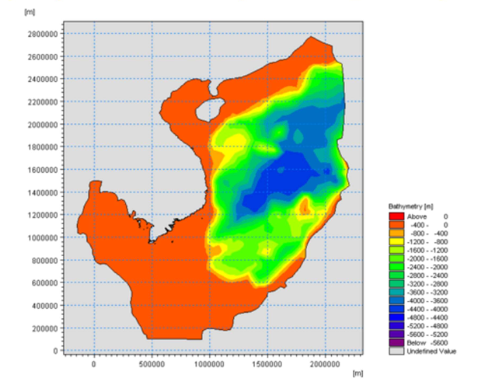
- Sonar surveys are commonly used for bathymetric mapping, which involves measuring the depth of water bodies such as oceans, lakes, and rivers. This information is crucial for navigation, environmental monitoring, and scientific research.
-
Seafloor Mapping:
- Sonar surveys are employed to map the seafloor and underwater terrain. This is important for geological studies, habitat mapping, and identifying potential hazards on the ocean floor.
-
Navigation and Hydrography:
- Sonar technology is used for hydrographic surveys to create detailed maps of underwater surfaces. These maps aid in safe navigation for ships, submarines, and other underwater vehicles.
-
Search and Recovery Operations:
- Sonar surveys are utilized in search and recovery operations to locate objects or wreckage on the ocean floor. This includes searching for lost ships, aircraft, or submerged structures.
-
Underwater Archaeology by Underwater surveying and Mapping service:
- Sonar surveys play a crucial role in underwater archaeology by helping archaeologists locate and map submerged archaeological sites, shipwrecks, and ancient structures without disturbing the seabed.
-
Pipeline and Cable Inspection:
- In the offshore industry, sonar surveys are used to inspect and monitor underwater pipelines and cables. This helps identify damage, corrosion, or any other issues that may require maintenance.
-
Fisheries and Marine Biology:
- Sonar surveys are employed in fisheries and marine biology to study fish populations and their behavior. This information is valuable for fisheries management and conservation efforts.
-
Environmental Monitoring:
- Sonar surveys contribute to environmental monitoring by assessing underwater habitats, detecting changes in the seafloor, and studying the impact of human activities on marine ecosystems.
-
Offshore Energy Exploration:
- Sonar technology is used in offshore energy exploration to survey the seabed and assess the geological characteristics of the ocean floor. This information helps in selecting suitable locations for offshore oil and gas exploration or renewable energy installations.
-
Dredging Operations:
- Sonar surveys assist in dredging operations by providing accurate information about underwater topography. This helps dredging teams plan and execute operations more effectively.
-
Military and Defense Applications:
- Sonar surveys have various military and defense applications, including submarine detection, mine countermeasures, and underwater surveillance.
-
Research and Scientific Studies by Underwater surveying and Mapping service:
- Sonar surveys are widely used in scientific research to study oceanography, marine geology, and the behavior of underwater ecosystems. The data collected contributes to a better understanding of the underwater environment.
Sonar survey services utilize different types of sonar systems, including multibeam sonar, side-scan sonar, and single-beam echo sounders, depending on the specific requirements of the survey. These services are essential for exploring and understanding the underwater world in various fields.
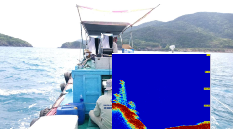
Dr. Nguyen Xuan Kha, who has over 23 years of experience in the field of geophysics, along with engineers from HCM University of Technology, has applied Chirp Sonar technology for high resolution of foreign objects underwater.
Please contact us at the hotline below for more information.