Underground Utility Locating and Mapping Services
1. Underground utility locating and mapping services?
Underground utility locating is crucial for identifying and mapping the location of various subsurface utilities, such as gas lines, water pipes, electrical cables, and telecommunication conduits. These services play a vital role in construction, infrastructure development, and maintenance activities to prevent accidental damage to utilities and ensure the safety of excavation projects. Here are key aspects and reasons for employing underground utility locating and mapping services
- Preventing Accidental Damage:
- One of the primary reasons for underground utility locating is to prevent accidental damage during excavation and construction activities. Knowing the precise location of utilities helps avoid incidents that could lead to service disruptions, injuries, or environmental hazards.
- Construction Planning and Design:
- Before commencing construction projects, it’s essential to understand the layout of existing underground utilities. Utility locating services provide valuable information for construction planning and design, enabling engineers to design around existing infrastructure.
-
Reducing Risks and Liabilities:
- Accidental damage to underground utilities can result in costly repairs, service disruptions, and legal liabilities. Utilizing utility locating services helps minimize these risks by providing accurate information about the location and depth of utilities.
- Ensuring Worker Safety:
- Underground utility locating services contribute to the safety of construction workers by providing information about potential hazards beneath the surface. This allows workers to take necessary precautions and follow safety protocols during excavation activities.
-
Compliance with Regulations of Underground Utility Locating and Mapping:
- Many regions have regulations and standards in place that require utilities to be located and mapped before excavation projects. Compliance with these regulations is essential for obtaining necessary permits and ensuring the safety and integrity of the project.
-
Efficient Project Execution:
- Knowing the precise location of utilities allows construction projects to proceed efficiently without unexpected delays. It facilitates the coordination of activities and helps avoid disruptions that may occur if utilities are damaged during excavation.
-
Utility Mapping for Asset Management:
- Utility locating services contribute to the creation of accurate utility maps and databases. These maps are valuable for asset management, maintenance planning, and future construction projects, ensuring efficient use of resources and reducing the risk of damage to existing infrastructure.
- Emergency Response Planning of Underground Utility Locating and Mapping:
- In emergencies such as natural disasters or utility failures, having accurate information about the location of underground utilities is crucial for emergency response planning. This includes quickly identifying and addressing utility issues to minimize the impact on communities.
-
Preserving the Environment:
- Accidental damage to underground utilities can lead to environmental contamination. By accurately locating utilities, environmental risks can be mitigated, preserving the integrity of soil and water resources.
-
Use of Advanced Technologies:
- Modern utility locating services often utilize advanced technologies such as ground-penetrating radar (GPR), electromagnetic induction, and GPS. These technologies enhance the accuracy of utility location, allowing for more precise mapping and minimizing the risk of errors.
In summary, underground utility locating and mapping services are essential for promoting safety, preventing damage to infrastructure, complying with regulations, and ensuring the efficient execution of construction and excavation projects. They are a critical component of responsible and sustainable infrastructure development.
3. The objectives of Underground Utility Locating and Mapping
– Using the GPR equipment to show two-dimensional profiles of the subsurface for
locating buried objects, and underground cable pipes.
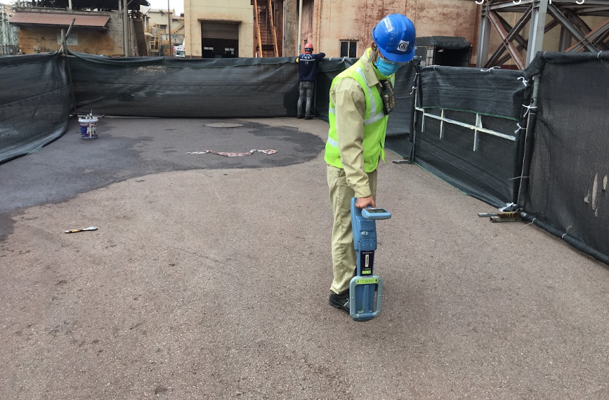
– Detecting underground cables by electromagnetic locator.
– Reporting the result in more detail.
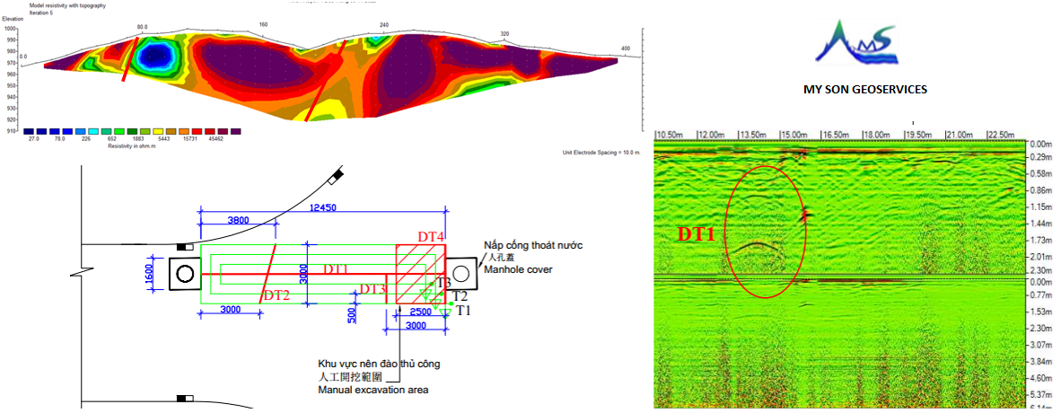
4. The underground utility locating and mapping results
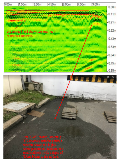
GPR Quantum Imager Q4-300 equipment simultaneously identifies shallow and deep underground objects at the same time with triple frequencies:
The first frequency is set up to 1.5m depth with high resolution to detect small and detailed objects
The second frequency is set up to 3m depth to detect common utilities.
The third frequency set up to 6m detects deep objects.
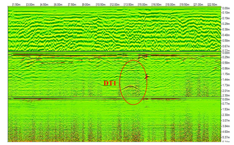
Based on ground-penetrating radar results: detect the underground objects.
Based on GPR results, the underground object DT1 on the routes, the depth from the surface to the subject is about 1.1m, and the underground object is likely related to an underground pipe.
Electromagnetic induction RD8000 device, detecting underground objects with a maximum depth of up to 6m. In this area, 02 underground objects are detected. The underground object with a depth from the surface to the object is about 0.9m, possibly related to the underground cable conduits. The underground object with about 0.8m depth from the surface to the object, is possibly related to the underground pipe or the noise signal from a heterogeneous ground medium.