Saturday, September 13, 2025

Sinkholes and Subsidence area location service

1. The detection and monitoring of sinkholes and subsidence areas

The detection and monitoring of sinkholes and subsidence areas involve geotechnical and geological assessments. Various technologies and services are employed to identify, assess, and manage the risks associated with these ground instability issues. Here are some services commonly used in the location and monitoring of sinkholes and subsidence areas:

  1. Geotechnical Surveys:

    • Conducting geotechnical investigations to understand the soil and rock properties at a site. This can involve drilling boreholes, collecting soil samples, and performing laboratory tests.
  2. Ground Penetrating Radar (GPR) for Sinkholes and Subsidence area location:

    • GPR is a non-invasive geophysical method that uses radar pulses to image the subsurface. It can help detect changes in soil density and identify potential subsurface features, including voids or cavities.
  3. Electrical Resistivity Tomography (ERT):

    • ERT is a geophysical technique that measures the electrical resistivity of the subsurface. It can be used to identify variations in soil composition, moisture content, and the presence of voids or cavities.
  4. Seismic Refraction Surveys:

    • Seismic surveys can be employed to assess the subsurface by measuring the speed of seismic waves. This information helps identify geological layers and potential subsurface anomalies.
  5. Drone Surveys:

    • Aerial surveys using drones equipped with various sensors, including LiDAR or photogrammetry, can provide detailed topographic information to identify surface depressions or changes.
  6. Satellite Imagery Analysis:

    • Remote sensing technologies, including satellite imagery, can be used to monitor land subsidence or surface changes over time. Advanced satellite systems provide high-resolution images for detailed analysis.
  7. Sinkhole Monitoring Instruments:

    • Installation of monitoring instruments such as inclinometers, extensometers, or settlement plates to measure ground movements and deformation over time.
  8. LiDAR (Light Detection and Ranging):

    • LiDAR technology uses laser beams to measure distances, providing detailed three-dimensional maps of the terrain. It’s effective in identifying changes in elevation and surface features.
  9. Risk Assessment and Modeling:

    • Utilizing geospatial data and geological models to assess the risk of sinkholes and subsidence in a particular area. This involves analyzing factors such as soil types, groundwater conditions, and historical events.
  10. Community and Infrastructure Risk Management:

    • Providing services to local communities and infrastructure managers to assess and manage the risks associated with sinkholes and subsidence. This includes developing mitigation strategies and emergency response plans.

It’s important to note that the specific services used may vary depending on the nature of the site, the geological conditions, and the scale of the project. Professionals in geotechnical engineering, geophysics, and environmental sciences typically provide these services to assess and address the risks associated with sinkholes and subsidence. If you have concerns about a specific location, consulting with experienced professionals is recommended for a comprehensive assessment.

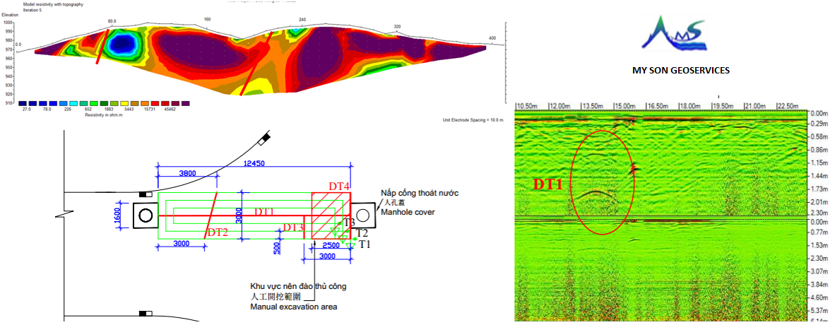
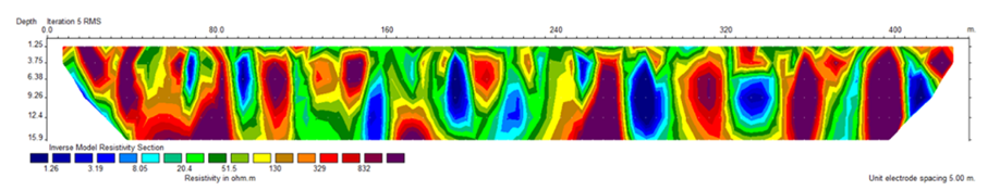
2. Results of electric resistivity tomography survey

The survey area has low resistivity values ​​ranging from a few ohms.m to several hundred ohms.m. Corresponding to the measured resistance parameters, it proves that the survey area is located on a young unconsolidated alluvial layer, weak sedimentary ground, when the leveling material is uneven, it will form uneven consolidation positions, leading to The geological structure of the surface layer up to 10m deep in the area is heterogeneous.

Sinkholes and Subsidence area location service by ERT survey

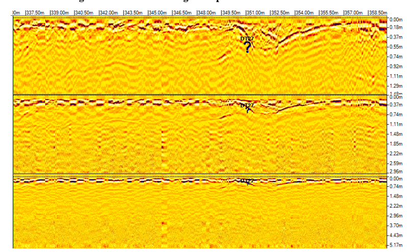
Ground-penetrating radar results detected anomalies related to slightly sunken and
deformed asphalt roadbeds. No anomalies related to deep sinkholes have been detected.

Sinkholes and Subsidence area location service by GPR survey

Contact consulting hotline Mr. Mam +84 963 247 151 E-mail: mysoncrsa@gmail.com