Groundwater prospection and mapping service
Why is it necessary to have underwater exploration services?
Groundwater prospection and mapping services involve the use of various geophysical and hydrogeological techniques to identify and characterize groundwater resources beneath the Earth’s surface. These services are crucial for sustainable water resource management, well-site selection, and groundwater exploration. Here are some key methods and considerations used in groundwater prospection and mapping:
- Geophysical Surveys:
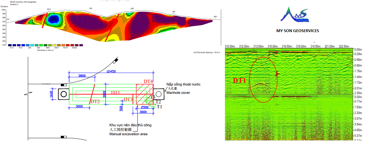
- Electrical Resistivity Tomography (ERT):
- Measures the electrical resistivity of subsurface materials. Variations in resistivity can indicate changes in lithology, helping to identify potential aquifers.
- Seismic Refraction:
- Measures the speed of seismic waves through subsurface layers, providing information on the depth and thickness of geological formations, including potential aquifers.
- Ground Penetrating Radar (GPR):
- Uses radar pulses to image the subsurface and detect variations in soil and rock properties, helping to locate potential water-bearing formations.
- Electrical Resistivity Tomography (ERT):
- Borehole Logging:
- Natural Gamma Logging:
- Measures natural gamma radiation emitted by subsurface materials, helping identify different lithologies and potential aquifers.
- Electrical Conductivity Logging:
- Measures the electrical conductivity of formation fluids, assisting in delineating saline and freshwater zones.
- Fluid Temperature Logging:
- Records temperature variations with depth, which can provide insights into the presence of groundwater flow.
- Natural Gamma Logging:
- Hydrogeological Studies:
- Aquifer Testing:
- Conducts pumping or injection tests in wells to assess aquifer characteristics, including transmissivity, storage, and hydraulic conductivity.
- Slug Tests:
- Involves introducing a small volume of water into a well and measuring the resulting water level changes to estimate aquifer parameters.
- Water Quality Analysis:
- Examines the chemical composition of groundwater to assess its suitability for various uses.
- Aquifer Testing:
-
Remote Sensing and GIS (Geographic Information System):
- Utilizes satellite imagery and aerial photographs to identify surface features and geological formations associated with potential groundwater resources.
- Integrates geospatial data to create groundwater potential maps, considering factors such as land use, slope, and geological formations.
-
Geological and Topographical Mapping:
- Analyzes geological maps and topographical features to identify areas with favorable conditions for groundwater occurrence.
- Considers factors such as the presence of fault zones, fractures, and permeable formations.
-
Data Integration and Modeling by Groundwater prospection and mapping:
- Integrates data from various sources, including geophysical surveys, borehole logs, hydrogeological studies, and remote sensing, to create comprehensive groundwater models.
- Models can help predict the spatial distribution of groundwater resources and guide sustainable management practices.
-
Groundwater Monitoring Networks:
- Establishes monitoring networks with wells strategically located to continuously measure groundwater levels, quality, and other relevant parameters.
-
Community Engagement:
- Engages with local communities and stakeholders to gather traditional knowledge and ensure that groundwater prospection and mapping align with community needs and priorities.
Groundwater prospection and mapping services play a vital role in ensuring sustainable access to clean water. These services help guide responsible groundwater development and management practices, especially in regions where groundwater is a critical source of freshwater. Consulting with hydrogeologists, geophysicists, and water resource experts is essential for the successful implementation of groundwater exploration projects.
To solve this problem, many households think that if they drill many holes, the deeper they drill, they will have water, but in fact, this is not the case, it depends on the geological conditions of the area, the amount of groundwater replenishment… Depending on the region, there will be different potential water reserves for exploitation. We need to know how to find and properly exploit this limited resource.
To meet that need, we provide underground water exploration ultrasonic search services .
Based on practical knowledge, professional ability, and scientific application to solve problems:
+ Exploring potential water sources.
+ Calculate the optimal well parameters:
+ Reasonable exploitation, saving money and time for our people.
The professionalism of the engineering team of Groundwater prospection and mapping?
Mr. Nguyen Xuan Kha, who has over 23 years of experience in the field of geophysics, together with engineers from Polytechnic University, has constantly tried to meet and exceed people’s expectations.
We always value our customers and always welcome any comments or suggestions you have.
Please Contact us to let us know what we did well or what we could improve.
Our objectives for Groundwater prospection and mapping services?
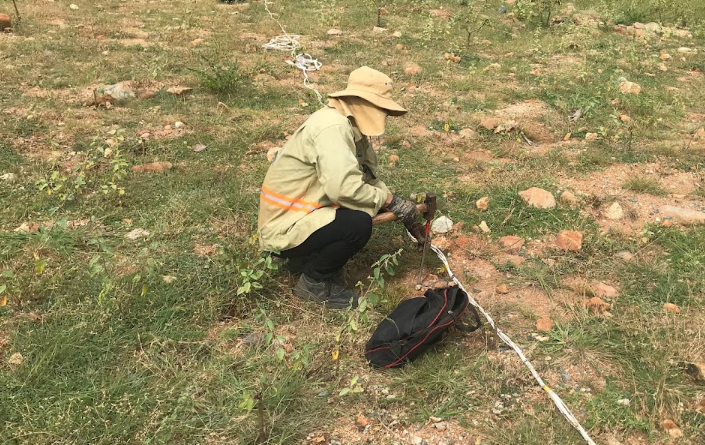
Underground water exploration and search services :
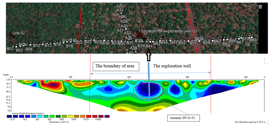
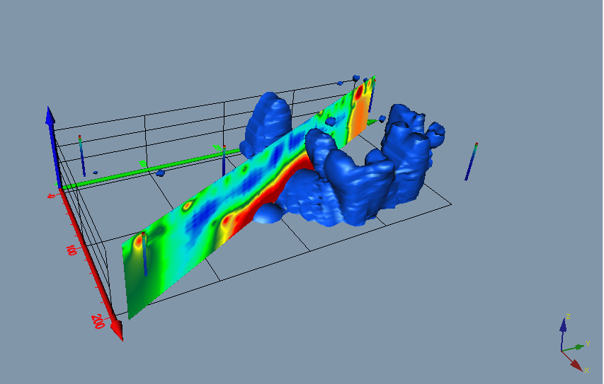
Applying geophysical methods of electric depth measurement to determine resistivity changes in geological layers, from receiving data, processing data, and applying specialized 2D, and 3D software to combine With our expertise and experience accumulated over many years, we can offer:
+ The most potential underground water area
+ depth to drill
+ location of drilling machine
+ proposed well structure
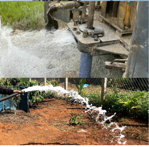
Underground water exploration services
Underground water exploration
Well-drilling services through areas where underground water has been explored:
From implementing underground water exploration contracts, we are ready to contract with customers to bring specialized drilling machines with experienced drilling teams to perform the drilling process.
Pipe protection ensures the long-term exploitation of water wells
Water pump supply service by Groundwater prospection and mapping:
Use down-suction pumping devices to determine hydrological parameters:
+ permeability of the water layer
+ water release coefficient
+ allowable water level lowering
+ Potential dynamic reserves for exploitation
+ Advise on the type of pump that customers should use
Well repair service:
After a period of exploiting underground water, our wells are often filled with sand and rock, blocking the filter tube, blocking water from entering the well, and reducing exploitation ability, so dredging is needed to restore the original exploitation ability. head.
Customer consulting
We will give the best advice to customers to ensure price and efficiency benefits.
Customers can contract separately for exploration, well drilling, or a combination.
“Prestige is our existence”