Why is an induction electromagnetic survey service needed?
For a large area of about 50 hectares. With normal vision, we can only detect strange objects and anomalies on the surface, but we cannot detect anomalies and underground objects. The option of drilling to detect is a very costly and time-consuming solution. To be most economical and effective, we need to: conduct measurements… localizing anomalous areas one step ahead is the most optimal solution for investors.
Electromagnetic conductivity surveys, terrain conductivity surveys, or EM surveys measure the conductivity of the subsurface which includes soil, groundwater, rock, and objects buried in the ground.
Myson, Inc. has conducted numerous electromagnetic conductivity surveys, terrain conductivity surveys, and EM surveys nationwide and worldwide using EM instruments for various applications.
An induction electromagnetic (EM) survey service needed for various purposes, primarily related to subsurface exploration and resource assessment. Induction EM surveys involve the measurement of electromagnetic fields induced in the Earth’s subsurface by a time-varying magnetic field. Here are some reasons why induction EM survey services are valuable:
-
Mineral Exploration:
- Induction EM surveys used in mineral exploration to detect the presence of conductive minerals. Different minerals exhibit distinct electrical conductivity, allowing geophysicists to identify potential mineral deposits beneath the Earth’s surface.
-
Oil and Gas Exploration:
- In the oil and gas industry, induction EM surveys are utilized to map subsurface resistivity and identify hydrocarbon-bearing formations. Hydrocarbons often exhibit different electrical properties than surrounding rocks, making EM surveys valuable in locating potential reservoirs.
- Groundwater Exploration:
- Induction EM surveys are employed in hydrogeological studies to map subsurface resistivity variations, helping to locate and characterize groundwater resources. Changes in resistivity can indicate the presence of aquifers or the movement of saline water.
-
Environmental Site Assessments:
- Induction EM surveys are used in environmental studies to assess soil and groundwater contamination. Variations in subsurface conductivity can indicate the presence of contaminants, aiding in the characterization and remediation of contaminated sites.
-
Geotechnical Investigations:
- For civil engineering projects, induction EM surveys help in assessing the subsurface conditions, including variations in soil composition and the presence of geological features. This information is crucial for foundation design and construction planning.
-
Archaeological Prospecting:
- Induction EM surveys applied in archaeology to identify buried structures, artifacts, and archaeological features. The method helps archaeologists locate potential sites without excavation, minimizing the impact on historical resources.
-
Monitoring Changes in Subsurface Conditions:
- Continuous or periodic induction EM surveys can be used to monitor changes in subsurface conditions over time. This is valuable for tracking variations in groundwater levels, detecting the movement of contaminants, or assessing the impact of human activities.
-
Pipeline and Cable Detection:
- Induction EM surveys are employed to locate and map underground utilities such as pipelines and cables. These surveys help prevent accidental damage during construction activities and contribute to the planning of infrastructure projects.
-
Mapping Geological Structures:
- Induction EM surveys contribute to mapping geological structures, fault lines, and variations in subsurface composition. This information is essential for understanding the geological history of an area and can aid in hazard assessment.
-
Research and Scientific Studies:
- Induction EM surveys are utilized in various scientific studies to investigate subsurface properties and processes. Researchers use these surveys to enhance their understanding of geological, environmental, and hydrological phenomena.
Overall, induction EM survey services play a crucial role in subsurface exploration and resource assessment across different industries, providing valuable information for decision-making in fields ranging from mineral exploration to environmental management.
Electromagnetic equipment?
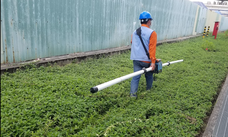
Electromagnetic EM31 equipment designs with one emitter and one collector.
The emitter, emitting an initial field (primary field), causes an induced current in the conductive object and then receives a secondary signal.
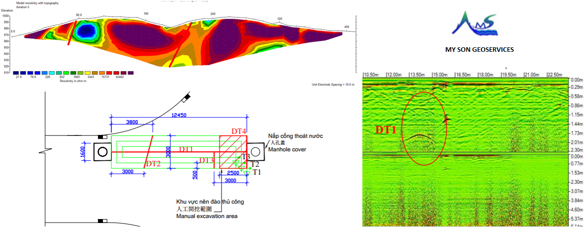
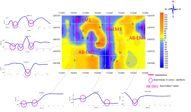
The task of EM field methods is to detect objects with high conductivity with a survey depth of 6m.
Based on the electrical conductivity map in the survey area:
Shows that the electromagnetic conductivity value ranges from 220 ÷ -160 mSm, and the electrical conductivity fluctuates quite large, detecting magnetic anomalies in the area, AB-EM1 and AB-EM2 are often shown quite clearly and may be related to buried conductive objects.
Customer consulting?
Field work was conducted by three engineers Nguyen Nam Tran Quoc Trung, and Nguyen Thang at the site.
Data analysis at the office by Dr. Nguyen Xuan Kha.
We will give the best advice to customers to ensure benefits in EM induction survey work.
Please contact our hotline at +84 963247151 or mail: mysoncrsa@gmail.com for overseas service
 Principle of Electromagnetic Induction Measurement Survey results